| Archives | Cordillera | Publications | International Work | Campaigns | Elders Work |Galleries | About Us | Home | |
 |
CAMPAIGNS |
|
Urban Issues |
|
|
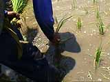
CORDILLERA PEASANTS, in previous times limited by local subsistence economies, have gradually turned to farming marketable crops in past decades. But now the formerly lucrative local vegetable market, wracked by import liberalization, has become treacherous. Above, a rice farmer in Tabuk, Kalinga is increasingly pressured to adopt HYV technology. CLICK ON PHOTOS FOR HIGH-RES VIEW.
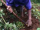
Potato farmers in Mankayan, Benguet appear to benefit from "modern" farm technology, but much of the work still involves tedious manual labor.
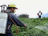
HYV technology for rice and other cash crops involve heavy use of pesticides and other expensive agro-chemical inputs.
Yes, HYV technology does produce more bountiful crops, as the name "high-yielding variety" itself implies. But only at first. Chemicalization of farming rapidly depletes the land's natural capacity to enrich itself, and soon, the farmers are crushed by high prices of imported chemical inputs. |
|
|
CAMPAIGN VS. Agricultural Liberalization Cordillera Agriculture Situationer The Northern Luzon Cordillera is the largest mass of mountains in the Philippine archipelago. The Cordillera Administrative Region, comprised of the provinces of Abra, Apayao, Benguet, Ifugao, Kalinga, and the Mountain Province, have an aggregate land area of more than 1.8 million hectares. Terrain, however, limits the availability of arable land in the area. The Cordillera is the most rugged group of mountain ranges in the Philippines. Elevations here vary from 10 meters at the bottom of river valleys to 2,900 meters on the mountaintops. The mountain ranges are heavily ridged. Their river valleys are narrow. Only along the foothills is there any flatland of significant extent. Nearly 61% of the region is sloped in excess of 50%. This makes the soil highly erosive and the topsoil layer fairly thin. Yet agriculture has been practiced here since before the 12th century, when people indigenous to the area carved their first terraces out of the steep mountainsides of western Ifugao and planted them to rice. Today, some 80% of the Cordillera’s population, both indigenous and migrant, engage in agricultural production as their main source of livelihood. Click here for full text of the article Statements and Articles: |
Published with financial contribution from the Swedish Society for Nature Conservation
Copyright © 2004 website content by Cordillera Peoples Alliance, Website design by Borky Perida |