| |
THE EVOLUTION OF CORDILLERA REGION'S ADMINISTRATIVE BOUNDARIES
The first Cordillera town was founded in 1599, in Bangued, as a mission
in what is now the province of Abra. A few other units of local administration
were established in the 18th century, along the fringes of the mountain
region. Colonially administered settlements were established among the
natives of the lower Abra river valley and among peoples in the area where
the Cordillera connects with the Caraballo mountains, in what is now the
province of Nueva Vizcaya.
Nueva Vizcaya was created as a military province in 1840, to protect
the settlements of subjugated Christians against frequent attacks from
their independent Cordillera and Caraballo neighbors. Another military
province was created in central Abra in 1846. Still another was established
in 1850 in La Union, whose population then was more Igorot than Ilocano.
La Union included a district called Benguet, which covered the present
Trinidad valley and neighboring areas, and which had been "pacified"
in the 1830s by infamous Spanish military commander Guillermo Galvey.
The first commandancies were formed in the 1840's and 1850's. The Tiagan
commandancy (1847) covered what is now the triboundary of Abra, Ilocos
Sur, and Mountain Province. The Bontoc commandancy (1852) covered the
area from Mainit to Banaue. The Lepanto commandancy (1852) covered the
area from Besao to Suyoc. The Benguet commandancy covered the stretch
from Buguias to Itogon. The Saltan commandancy (1859) covered the area
from Pinukpuk to Tinglayan.
From the 1880s to the 1890s, the Spanish colonialists reorganized old
commandancies and created new ones. The Saltan commandancy was replaced
by the Itaves, which stretched from Ripang (near present-day Conner) through
Bulanao (in present-day Tabuk) to a point in what is now Paracelis. Lubuagan,
Tanudan and Tinglayan were placed under the Bontoc commandancy, which
no longer included Banaue. Banaue was placed under the new Kiangan commandancy
(1889) that covered most of what is now Ifugao province.
Other new commandancies were formed in 1891: Kayapa in what is now the
border area of Benguet, Ifugao and Nueva Vizcaya; Amburayan in what is
now Ilocos Sur; and Apayao around the Pudtol area. The Kabugaoan commandancy
was supposed to cover Calanasan-Kabugao area of Apayao and the Tineg area
of Abra, but its existence remained only on paper.
After the Americans defeated the Filipino revolutionaries, they established
their own Cordillera boundaries that closely approximated those of the
Spanish commandancies. The US colonial authority set up Mountain Province
in 1908 as a "special province", organized into several sub-provinces:
Apayao, Kalinga, Bontoc, Ifugao, Benguet, Lepanto, and Amburayan.
The Americans retained Abra, La Union and Nueva Vizcaya as units separate
from Mountain Province, despite the fact that Abra geographically and
culturally belonged to the Cordillera, and that considerable portions
of the populations of La Union and Nueva Vizcaya then consisted of mountain
peoples.
In 1917, the US colonial government's Bureau of Non-Christian Tribes
recommended that the western border of the Mountain Province be pushed
eastward, such that the entire subprovince of Amburayan and large slices
of Lepanto and Benguet would be made part of Ilocos Sur and La Union.
The adjustment was made in 1920. Also, the subprovince of Lepanto was
dissolved, and its various towns and villages turned over to Ilocos Sur,
Benguet, or Bontoc.
The old Mountain Province would be retained under the Philippine Commonwealth
in 1935 and under the Republic of the Philippines from 1946 onwards for
the next 20 years.
In 1966, the old Mountain Province was divided into four new provinces:
Kalinga-Apayao, Ifugao, Benguet, and Bontoc (which retained the name Mountain
Province).
In 1972, martial law paved the way for a wide-ranging government reorganization.
The Cordillera provinces were placed under two regions: with Benguet and
Mountain Province falling under Region 1 (Ilocos) and Kalinga-Apayao and
Ifugao falling under Region 2 (Cagayan Valley).
In 1988, two years after Marcos was ousted, the mountain provinces were
reconsolidated as the Cordillera Administrative Region, this time including
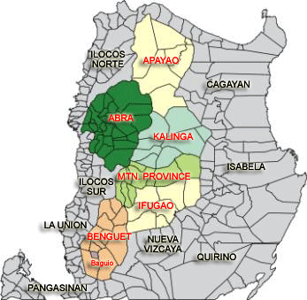
Abra. In 1995, Kalinga and Apayao became separate provinces. #
|
ADMINISTRATIVE DIVISIONS OF THE
CORDILLERA REGION
Apayao province
| land
area (sq km) |
|
| 2000
population |
|
| capital
town |
|
| no. of towns |
7 |
| no. of barangays |
133 |
Kalinga province
| land
area (sq km) |
|
| 2000
population |
|
| capital
town |
|
| no. of towns |
8 |
| no. of barangays |
152 |
Abra province
| land
area (sq km) |
|
| 2000
population |
|
| capital
town |
|
| no. of towns |
27 |
| no. of barangays |
303 |
Mountain
Province
| land
area (sq km) |
|
| 2000
population |
|
| capital
town |
|
| no. of towns |
10 |
| no. of barangays |
144 |
Ifugao province
| land
area (sq km) |
|
| 2000
population |
|
| capital
town |
|
| no. of towns |
11 |
| no. of barangays |
175 |
Benguet province
| land
area (sq km) |
|
| 2000
population |
|
| capital
town |
|
| no. of towns |
13 |
| no. of barangays |
269 |
Baguio City
| land
area (sq km) |
|
| 2000
population |
|
| no. of barangays |
129 |
|